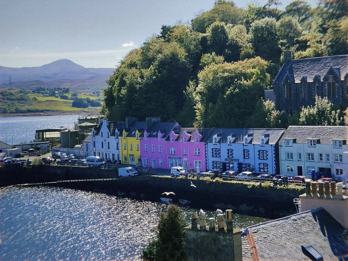
Portree is a harbour town on Skye, with a colourful waterfront and hills rising behind it. It provides a useful island base, but living here involves different travel choices from mainland towns. Compare the island setting and local facilities with your need to reach larger centres, family or airports.
About this score
The UK index averages 19 supported comparisons. Weather, walking style and your important places need a personal preference and are excluded. Affordability compares supported area prices, with lower prices ranked higher. Crime is compared within each recording nation. Your suitability uses the priorities you choose.
Your home
Homes & affordability
Area estimate
UK comparison Good
Very poorExcellent
£224,574 supported area price
authority HPI
Details & source
Official UK HPI authority-area average; not a village sample or property valuation
Lower area prices. The comparison bar shows relative position, not a guarantee for an individual property.
Flood screening
Area data
UK comparison Good
Very poorExcellent
0/100 exposure index (lower means less screened exposure)
Official settlement-centre screen; check surface water and the property
Details & source
Official national centre-screening · official centre-screen, incomplete hazard coverage · relative screening index, NOT annual flood probability
Compared with supported UK locations. The comparison bar shows relative position, not a guarantee for an individual property.
Council tax
Area data
UK comparison Excellent
Very poorExcellent
Highland
£1,687 per year (reference band)
Details & source
Official 2026/27 authority council tax or NI domestic-rate context
Compared with supported UK locations. The comparison bar shows relative position, not a guarantee for an individual property.
Historic character
Area data
UK comparison Very good
Very poorExcellent
26 listed buildings within 1 km
Details & source
Statutory listing-density context; not period homes for sale
Compared with supported UK locations. The comparison bar shows relative position, not a guarantee for an individual property.
Your surroundings
Low-density surroundings
Area data
UK comparison Poor
Very poorExcellent
4.5% mapped building footprint within 1 km
Details & source
OSM building-footprint share within 1 km; mapped built-upness, not a population census or guaranteed privacy
Lower building density. The comparison bar shows relative position, not a guarantee for an individual property.
Everyday essentials
Area data
UK comparison Excellent
Very poorExcellent
0.1 km straight-line
Details & source
OSM nearest grocery / everyday food shop, straight-line proximity, no count bonus
Compared with supported UK locations. The comparison bar shows relative position, not a guarantee for an individual property.
Outdoors & walking
Mapped paths & terrain
Fewer mapped pathsMore mapped paths
30.7 km of mapped paths within 3 km
4.5% building footprint; rural character affects countryside-walk fit
Details & source
Mapped path length within 3 km. Select parks, countryside, hills or mountains to assess your preferred type of walking.
Mapped paths are not necessarily countryside paths. Building density and hill or mountain access are used only when those walking preferences are selected.
Air quality
Area estimate
UK comparison Excellent
Very poorExcellent
3 μg/m³ PM2.5
Details & source
Defra/Ricardo Pollution Climate Mapping 2024 modelled PM2.5 + NO2 at 1-km background grid; not roadside/property measurement
Compared with supported UK locations. The comparison bar shows relative position, not a guarantee for an individual property.
Compared with supported UK locations. The comparison bar shows relative position, not a guarantee for an individual property.
Getting around
Your important places
Add your places
Add the places you want to stay close to.
Details & source
Distances use your selected destinations.
Rail connections
Area estimate
UK comparison Very poor
Very poorExcellent
Kyle of Lochalsh
51 min modelled road/ferry access
55.4 km on the road model
Static road/ferry model; excludes traffic and ferry waits.
Duirinish: 8 min published direct train journey
Plockton: 13 min published direct train journey
Details & source
Directed OSM static road/ferry model to up to three distinct mapped stations; inverse-distance-weighted network minutes, no traffic, waits or service-frequency guarantee; supplementary 20% verified service: 2026 Oct GB national-rail or Northern Ireland published timetables; station frequency/direct destinations and published train journey times, combined with V13 static road/ferry model to station; no live journey guarantee
Compared with supported UK locations. The comparison bar shows relative position, not a guarantee for an individual property.
Passenger airports
Area estimate
UK comparison Very poor
Very poorExcellent
Inverness Airport
178 min modelled road/ferry access
195.5 km on the road model
Static road/ferry model; excludes traffic and ferry waits.
Details & source
Directed OSM static road/ferry model to up to three distinct OurAirports scheduled-service airports; inverse-distance-weighted network minutes, no traffic, waits or service-frequency guarantee; supplementary 20% verified service: CAA UK airport passenger reporting, 2025 total passenger traffic and scheduled international routes; not a live airline timetable
Compared with supported UK locations. The comparison bar shows relative position, not a guarantee for an individual property.
Major-road access
Area data
UK comparison Excellent
Very poorExcellent
Motorway junction / primary A-road
1 min estimated drive
0.1 km on the road model
Recorded road-network distance; time estimated at 40 km/h, excluding traffic.
Details & source
Measured road-network distance 0.09 km to an accessible motorway junction or primary A-road. UK settlement empirical percentile; no road-class multipliers. Separate recorded distances: motorway 307.091 km, primary A 0.087 km, other A 172.631 km. Driving distance is NOT travel time.
Compared with supported UK locations. The comparison bar shows relative position, not a guarantee for an individual property.
Everyday life
Schools nearby
Area estimate
UK comparison Excellent
Very poorExcellent
0.4 km straight-line
National inspections retained in original form; rating measures school access
Details & source
Measured nearest-school proximity only. Scotland/Wales/NI inspectorates are not converted into Ofsted grades.
School access and comparable published inspections. The comparison bar shows relative position, not a guarantee for an individual property.
Healthcare access
Area data
UK comparison Excellent
Very poorExcellent
Portree Medical Centre
0.2 km straight-line
0.3 km to mapped hospital
Details & source
50% registered NHS GP proximity, 35% mapped hospital proximity, 15% mapped pharmacy proximity; public postcode centroids / OSM, not capacity or clinical quality
Compared with supported UK locations. The comparison bar shows relative position, not a guarantee for an individual property.
Lower recorded crime
Area estimate
National comparison Below average
Very poorExcellent
43 recorded crimes per 1,000 residents
2025-26
Details & source
Scottish council area: Highland
Compared within the same recording nation. The comparison bar shows relative position, not a guarantee for an individual property.
Eating & drinking
Area data
UK comparison Excellent
Very poorExcellent
0 km straight-line
Details & source
OSM nearest pub, café or restaurant; proximity, not ratings or opening hours
Compared with supported UK locations. The comparison bar shows relative position, not a guarantee for an individual property.
Lifestyle & future
Coastal access
Area data
UK comparison Excellent
Very poorExcellent
0.1 km to coastline
Details & source
Mapped coastline distance; straight-line distance, not a route
Compared with supported UK locations. The comparison bar shows relative position, not a guarantee for an individual property.
Weather & climate
Observed weather
Cooler / wetterWarmer / drier
8.5°C mean temperature
2,549 mm rainfall
1,048 sunshine hours
Details & source
Met Office observations for the recorded 12-month period, not long-term normals. This range combines observed temperature, rainfall and sunshine; it is not a good/bad rating.
Compared with supported UK locations. The comparison bar shows relative position, not a guarantee for an individual property.
Mobile coverage
Area estimate
UK comparison Very poor
Very poorExcellent
Outdoor coverage across the local authority
Details & source
Ofcom Jan 2026 outdoor geographic coverage (at least one network), published by ONS Explore Local Statistics; local-authority area, NOT a village or indoor signal reading
Compared with supported UK locations. The comparison bar shows relative position, not a guarantee for an individual property.
Employment context
Area data
UK comparison Average
Very poorExcellent
73.9% working-age employment
1 jobs per working-age resident
Details & source
ONS/NISRA labour conditions: 65% workplace job-density fit + 35% working-age employment fit when both exist; otherwise published component only. Survey uncertainty; not vacancies or an individual job match
Area employment and job availability. The comparison bar shows relative position, not a guarantee for an individual property.